State of the site at the liberation of the camp, as recorded
by the Soviet Commission
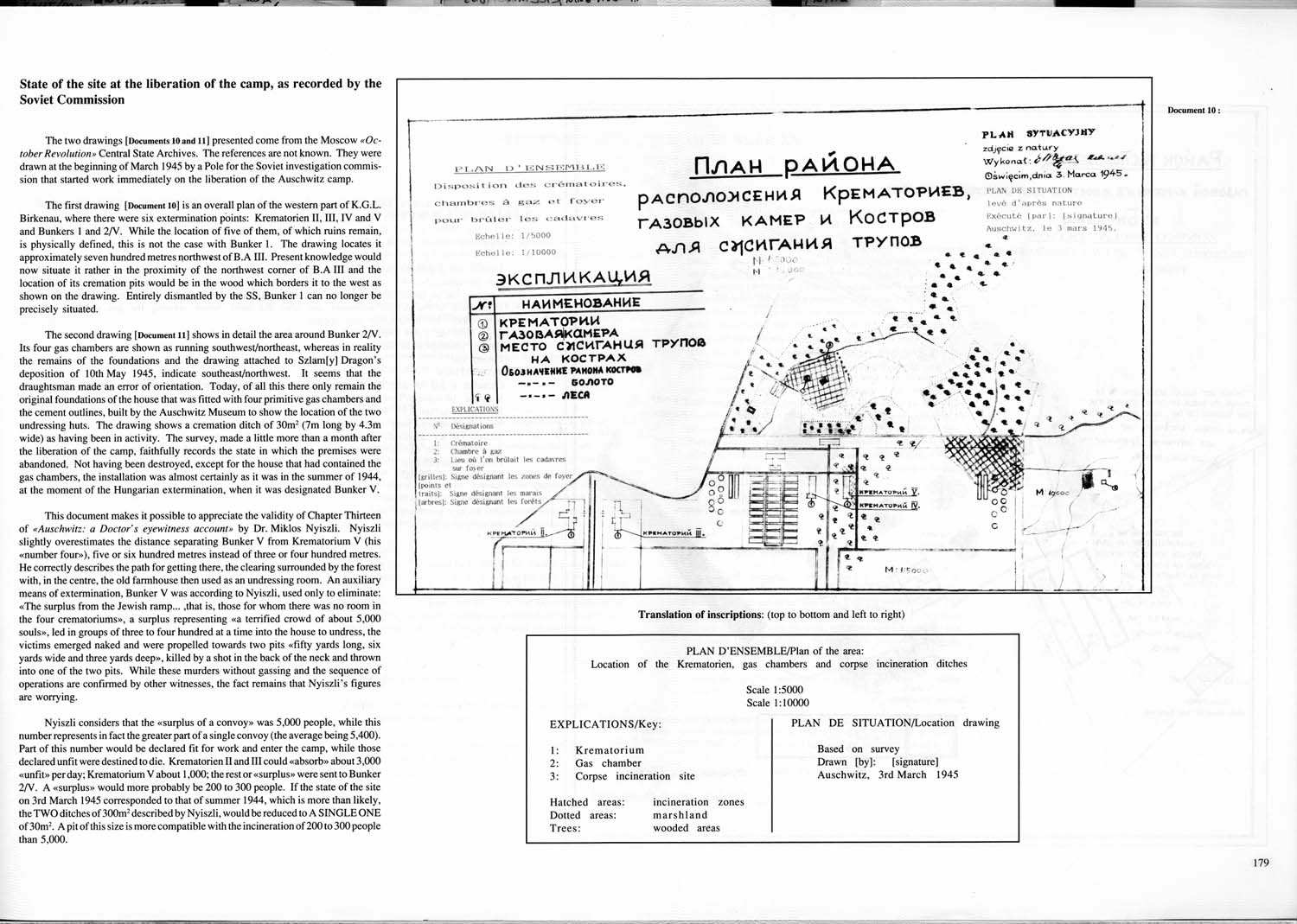
The two drawings [Documents 10 and 11] presented come from the Moscow “October Revolution” Central State Archives. The references are not known. They were drawn at the beginning of March 1945 by a Pole for the Soviet investigation commission that started work immediately on the liberation of the Auschwitz camp.
The first drawing [Document 10] is an overall plan of the western part of K.G.L. Birkenau, where there were six extermination points: Krematorien II, III, IV and V and Bunkers 1 and 2/V. While the location of five of them, of which ruins remain, is physically defined, this is not the case with Bunker 1. The drawing locates it approximately seven hundred meters northwest of B.A. III. Present knowledge would now situate it rather in the proximity of the northwest corner of B.A. III and the location of its cremation pits would be in the wood which borders it to the west as shown on the drawing. Entirety dismantled by the SS, Bunker 1 can no longer be precisely situated.
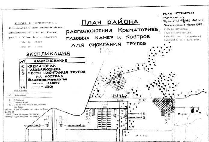
The second drawing [Document 11] shows in detail the area around Bunker 2/V. Its four gas chambers are shown as running southwest/northeast, whereas in reality the remains of the foundations and the drawing attached to Szlam[y] Dragon’s deposition of 10th May 1945, indicate southeast/northwest. It seems that the draughtsman made an error of orientation. Today, of all this there only remain the original foundations of the house that was fitted with four primitive gas chambers and the cement outlines, built by the Auschwitz Museum to show the location of the two undressing huts. The drawing shows a cremation ditch of 30m² (7m long by 4.3m wide) as having been in activity. The survey, made a little more than a month after the liberation of the camp, faithfully records the state in which the premises were abandoned. Not having been destroyed, except for the house that had contained the gas chambers, the installation was almost certainly as it was in the summer of 1944, at the moment of the Hungarian extermination, when it was designated Bunker V.
This document makes it possible to appreciate the validity of Chapter Thirteen of “Auschwitz: a Doctor’s eyewitness account” by Dr. Miklos Nyiszli. Nyiszli slightly overestimates the distance separating Bunker V from Krematorium V (his “number four"), five or six hundred meters instead of three or four hundred meters. He correctly describes the path for getting there, the clearing surrounded by the forest with, in the center, the old farmhouse then used as an undressing room. An auxiliary means of extermination, Bunker V was according to Nyisli, used only to eliminate: “The surplus from the Jewish ramp … …that is, those for whom there was no room in the four crematoriums”, a surplus representing a “terrified crowd of about 5,000 souls”, led in groups of three to four hundred at a time into the house to undress, the victims emerged naked and were propelled towards two pits “fifty yards long, six yards wide and three yards deep”, killed by a shot in the back of the neck and thrown into one of the two pits. While these murders without gassing and the sequence of operations are confirmed by other witnesses, the fact remains that Nyiszli’s figures are worrying.
Nyiszli considers that the “surplus of a convoy” was 5,000 people, while this number represents in fact the greater part of a single convoy (the average being 5,400). Part of this number would be declared fit for work and enter the camp, while those declared unfit were destined to die. Krematorien II and III could “absorb” about 3,000 “unfit” per day; Krematorium V about 1,000; the rest or “surplus” were sent to Bunker 2/V. A “surplus” would more probably be 200 to 300 people, If the state of the site on 3rd March 1945 corresponded to that of summer 1944, which is more than likely, the TWO ditches of 300m² described by Nyiszli, would be reduced to A SINGLE ONE of 30m². A pit of this size is more compatible with the incineration of 200 to 300 people than 5,000. |
|
| Document 10 |
 |
|
Translation of inscriptions: (top to bottom and left to right)
PLAN D'ENSEMBLE / Plan of the area:
Location of the Krematorien, gas chambers and corpse incineration ditches
Scale 1:5000
Scale 1:10000 |
| |
EXPLICATIONS / Key: |
|
| |
1: Krematorium |
|
| |
2: Gas chamber |
|
| |
3: Corpse incineration site |
|
| |
Hatched areas: incineration zones |
|
| |
Dotted areas: marshland |
|
| |
Trees: wooded areas |
|
| |
PLAN DE SITUATION / Location drawing |
|
| |
Based on survey
Drawn [by]: [signature]
Auschwitz, 3rd March 1945 |
|
|